Overview
Personal Map Server is an http server that publishes maps and other geospatial content via industry standard protocols for geospatial desktop and server applications to consume and use. Map Authors use the Map Publisher Desktop application to build and style maps and then publish those maps to Personal Map Server so they can be shared via the Intranet / Internet with other users.
Http Server
At the core of Personal Map Server is an http server that conforms to the HTTP / 1.0 protocol standard. The http server is part of the Personal Map Server Desktop application and can only run only while the desktop application is open. This is intentional because Personal Map Server was designed to be an easy alternative to running a full blown http server like Microsoft IIS on every map authors workstation. The server is useful for previewing maps before they are published to Enterprise Map Server and to share content easily with other trusted users on the Intranet. The Enterprise Map Server component runs under Microsoft IIS Server which is a robust http server and has many features that go beyond the scope of the Personal Map Server.
The http server by itself is a fairly fast and scalable web server that can deliver static content (files) much like any other web server although it only supports the GET, POST and HEAD command which makes it pretty simple. The real power of Personal map Server is implemented in the FastCGI modules that come with the server and are described in more detail below. The FastCGI protocol is a fast, scalable and fault tolerant protocol that enables the http server to run as quickly and as stable as possible. The http server is responsible for controling the lifespans of the CGI and FastCGI modules and directing http traffic to the appropriate handler. Users can expand the functionality of the server by placing their own content and services under the http server Home, Cgi-Bin or Virtual Directory paths and the server will deliver or execute the content. There are four FastCGI map services that are responsible for delivering map content and they are listed below:
Map Services Diagram
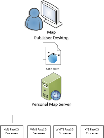
Map Services List
- OGC Keyhole Markup Language Service (KML)
An image tile service that deliveres KML and PNG or JPEG files that Google Earth, Google Maps and other applications and / or services that can consume KML formatted content. - OGC Web Mapping Service (WMS)
An image service that delivers XML and PNG or JPEG files to geospatial applications and services that can consume WMS services like ESRI ArcMap. - OGC Web Map Tile Service (WMTS)
A tiled image service that delivers XML and PNG or JPEG files to geospatial applications and services that can consume WMTS services like ESRI ArcMap. - OSM Map Tile Service (XYZ)
A tiled image service that delivers PNG or JPEG files to geospatial applications and services that can consume XYZ services like the web based OpenLayers map GUI application.
Note: OGC stands for Open Geospatial Consortium which is an international geospatial standards commitee. To learn more about the OGC please visit their website.
Note: OSM stands for Open Street Map which is a open repository of rasterized vector content. To learn more about the OSM please visit their website.
To read more about publishing maps and data via the KML, WMS, WMTS and XYZ service please refer to the help guide for Map Publisher Desktop.
Documentation is published by LCIC with the Axis release and imported here in full. Screenshots and wording are the vendor's own.